
Hikes in Høvringen
Well said by Jacob Weidemann: "I like myself at Høvringen because I feel it is the heart of Norway. There's a freedom here that you don't get anywhere else, not even at sea, because you don't have the view there—a total sovereign freedom..."
To Smuksjøseter
Høvringen - Smuksjøseter ca. 5 km – about 2 hours
Along the north side of Høvringsåe up to the road at the northern end of Lake Høvringsvatne and further on this to Smuksjøseter. Animal graves up on the eastern slope towards Kjøndalsbekken.

Peer Gynt Cabin
Peer Gynt hytta (cabin) – ca. 20 km roundtrip, about 7-8 hours
Start from the flagpole in the hotel garden. Follow the path down through the garden, out the gate and down onto the littleStart from the flagpole in the hotel garden. Follow the path down through the garden, out the gate and down onto the dirt road. Cross the road and walk to the parking lot (Ivars Plass).
Follow the trail that goes on the south side of Rondane Haukeliseter. Then turn right where the trail splits towards Haukberget and Peer Gynt Hytta. Then follow the trail on the south side of Vesleberget, then continue straight ahead where the trail turns off to Formokampen. Here you will then see Formokampen in its great profile. Dry terrain and periods somewhat wet on Merraslettin.
Follow the trail that goes on the south side of Rondane Haukeliseter. Then turn right where the trail splits towards Haukberget and Peer Gynt Hytta. Then follow the trail on the south side of Vesleberget, then continue straight ahead where the trail turns off to Formokampen. Here you will then see Formokampen in its great profile. Dry terrain and periods somewhat wet on Merraslettin.
After about 2 km, the trails from Høvringen and Putten Seter meet and continue on to the Peer Gynt cabin. Eventually, the terrain will open up and you will get a great view of Rondane. 2,5 km before the Peer Gynt Cabin, the trail turns left up towards Baksidevassberget.Just before Peer Gynt Hytta you cross over the river Ula, a nice gorge, where you can take beautiful pictures.
After a break at the Peer Gynt cabin, you cross Ula again and continue past Høvringsvatnene towards Smukjsøseter. Some rough terrain and some wet sections. Follow the road from Smuksjøseter to the end of the lake, then continue for 100 meters and enter the path to the left.... (more) Follow the trail straight ahead along Høvringsåe down to Høvringen. Just before you come down to Høvringen, you cross the bridge over Høvringsåe and after 100 meters you pass the famous landmark Høvringsporten (photo-spot). Then follow the trail down to the starting point.

Høvringen Cultural Trail
Høvringen Cultural Trail ca. 6 km, about 1.5 hour
The trail starts from Høvringen Handel & Kro, and it is marked with poles with horseshoes. Follow the little road across the road by the small shop. You can choose to walk parts of the trail.
The trip goes in easy and dry terrain. The trail goes along Høvringsåe, with waterfalls and potholes. Here you see interesting geology. Below the top bridge: Høvringsfossen waterfall and Høvringsporten.
Kvannslådalsbue round tour
Kvannslådalsbue -roundtrip – ca. 11 km, about 3-4 hours
Exit the main gate on the right. Cross the road and follow the trail and continue the cabin road past Høvringen Fjellalter. At the junction of the mountain altar one takes the direction to up tilted direction. A nice and dry path inland with an easy incline.
After approx. 2 km you will reach a junction where you can choose whether you want to walk over Kvannslådalsåe and continue down to Høvringen or you can follow the trail straight ahead and get to Bleikstulen and Høvringen. You will then enter the green-marked loop at Høvringen and can feel it south to the starting point.
Haukberget and Baksidevassberget
Haukberget/ Baksidevassberget ca. 3 km both ways, about 1.5 hour
Start from the flagpole in the hotel garden. Follow the path down through the garden, out the gate and down onto the dirt road. Cross the road and walk to the car park (Ivars Plass), follow the blue-marked path on the south side of Rondane Haukliseter Fjellhotell towards Vesleberget. Turn left where the trail splits towards Haukberget and Peer Gynt Hytta. After 500 meters you get the King's Stone on your left hand. From there there is a steep climb up to the top of Haukberget.
From the top of Haukberget, you take a path that is not physically marked, where you follow the peaks towards Baksidevassberget. Eventually, you will encounter a demanding party that you can choose to walk around. Here it is important to follow the map.
After approx. 2.5km you will reach a plateau where it is marked up towards the top of Baksidevassberget.
Putten – Kampen
Start from the parking lot in Putten. Car can be parked at Putten. If several people walk together, a car can be parked at Kampen or if you want to go to Smuksjøseter Fjellhotell, at Smuksjøseter. Follow the road down towards the bridge, and on until it ends at Skardseter. Then follow the marked path up towards the cairns at Skardfjellet. There you have great views of Gudbrandsdalen and Jotunheimen. Eventually, it becomes swampy and wet terrain for a while, until you approach Kampen. After a while, you pass Rukinsetra. Towards Kampen there will be more mountains and rocks, and when you enter the cabin area. Then you can follow the road inland towards the Peer Gynt hut. From the Peer Gynt cabin, cross Ula, before continuing on the bruised trail past Lake Høvringsvatnet towards Smuksjøseter Fjellstue.
Høvringen – Grimsdalshytta
Høvringen – Grimsdalshytta
Approx. 9 hour long tour. Extra demanding! See tour description at ut.no
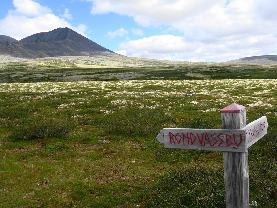
Rondvassbu
From Smuksjøseter:
Southeast in the direction of Søre Høvringsvatnet, nice view towards Smiubelgin. Over Kjøndalsbekken and then over Bråkdalsbekken on a summer bridge. Close to the old stone hut, Uløyhytta. Over to the Peer Gynt cabin (serving in high season). Further to Rondvassbu approx. 3.5 hours. Up to the east on the southern slope of Smiubelgin and past Ljosåbue. Further over Ljosåe and between Vesleranden and Randen past animal graves. Krokåtbekken and Kluftin are crossed, and at Rondvatnet the deep gorge Jutulhogget is passed. Over Store Ula on a year-round bridge at the trailhead to Dørålseter and Veslesmeden and over to the road and along this from Rondvassbu.

Bråkdalsbelgen
Peer Gynt Hytta - Bråkdalsbelgen, approx. 6 km round trip – Challenging climb, approx. 4-5 hours. See tour description at ut.no

Formokampen
Høvringen – Formokampen ca. 14 km both ways – about 4-5 hours
Start from the flagpole in the hotel garden. Follow the path down through the garden, out the gate and down onto the little rolad. Cross the road and walk to the parking lot (Ivars Plass).
Follow the red and blue path towards Merraslettin and the Peer Gynt hut. Gentle climb the first two kilometres before passing on the west side of Vesleberget. Relatively flat for the next two kilometres up to Skjærungåe. (The river can have relatively large flows in spring and with heavy rainfall, so some wading may occur.)
Gentle climb the next 2.5 kilometres up to the crest. In the last kilometre it will be relatively steep and some rocky surfaces. (The comb itself.) It is also possible to walk over the comb, where the trail comes up, and follow the "sinker" up to the top. In this route you also pass some nice animal graves on the way up.
At the top (1428 masl) you have, in clear weather, a fantastic view of Rondane, Jotunheimen and Dovrefjell, among others. In 2012, a sight plate was installed with information about what you see around you. Also at the top is Rondane's most recent confirmed discovery of a capture facility in Rondane (confirmed June 2011)
Kjondalen round tour
Kjondalen – Peer Gynt Hytta – Smuksjøseter ca. 11 km. About 4-5 hours
Start from Smuksjøseter Fjellhotell, follow the little road approx. 200 m. Then turn onto the blue trail marked from the main road just north of the end of the lake. Easy and dry terrain. Then you come to the Kjøndalen/Steindalen cross.
Then follow the trail straight ahead, after a bit the valley opens up and you follow the blue trail. After approx. 2.5 km you reach the crossing Kjøndalen / Solsidevassberget, here you continue straight on to Peer Gynt Hytta.
From the Peer Gynt cabin you cross Ula (river) and continue on the blue trail past Høvringsvatnet lake towards Smukjsøseter Fjellstue.

Karihaugen and Anaripigg
Karihaugen/ Anaripigg – ca. 5 km roundtrip, about 2-3 hours
Start from the flagpole in the hotel garden. Follow the path down through the garden, out the gate and down onto the little road. Follow the road over the bridge, cross the road and follow the path along the parking lot (Ivars Plass) Then follow the road down to the intersection cross county road / Puttenvegen.
The blue path to Anaripigg starts immediately from at the junction of county road/Puttenvegen west through the cabin field at Roa.
Continue further approx 1 km and then you come to a trail junction where the trail turns east towards Anaripigg. After approx. 800 meters you reach the top.
From Anaripigg to Karihaugen you follow the blue trail to Karihaugen approx. 800 meters. Continue on the blue path down towards Høvringen and you will pass Anarivatn on your way to Høvringen.
Vardhøe round tour
Vardhøe – ca. 8 km roundtrip, about 3 hours
Exit the main gate, turn right and follow the road for about 100 meters. Then turn right onto a little road, which after about 50 meters leads into a path. Follow the trail until you reach the dirt road. You follow this upwards to Høvringen mountain altar. After Høvringen mountain altar, follow the trail towards Vardhøe.
Good and dry path with easy climb to the crest of the mountain. There the trail splits and then follow the bruised path and after a few meters you enter the path that goes to the top. Here there is a steep slope before you reach the plateau towards even the top with a great large cairn – hence the name.
’Then continue on the blue trail towards Skogsetrene, after a few hundred meters you come onto the old trail Høvringen – Skogsetrene. The blue trail goes to Høvringen through the cliff, where there are a couple of wet sections before entering the blue path from Dovrehytta and then back to Høvringen.Then continue on the blue trail towards Skogsetrene, after a few hundred meters you come onto the old trail Høvringen – Skogsetrene. The blue trail goes to Høvringen through the cliff, where there are a couple of wet sections before entering the bruised path from Dovrehytta and then back to Høvringen

Kluftåthaugen
Kluftåthaugen, ca. 3.5 km, one way about 2 hours
Start from the flagpole in the hotel garden. Follow the path down through the garden, out the gate and down onto the little road. Cross the road and walk to the parking lot(Ivars Plass), follow the blue path , cross Puttenvegen, on the other side you will see signs towards Karihaugen and Anaripigg. Follow the trail between Stripåtmyrin and Anarivatn.
Then follow the trail further up towards Karihaugen. Relatively steep climb for a short distance. From Karihaugen to Anaripigg you follow the blue path approx 800 meters. From Anaripgg the trail splits so that you can continue on to Hårrtjønnin and Kluftåthaugen.After approx. 1 km you will reach a junction and there you will take on the blue path towards Kluftåthaugen.
First you go uphill over Hårrtjønnhøe, then down and look straight down into Gudbrandsdalen towards Sel, 800m down. Furthermore, the trail runs on bedrock/large slabs and can be a bit slippery in rainy weather. A lot of blueberry heather down towards the forest. Inside the forest, the trail goes up towards Kluftåthaugen.
From Kluftåthaugen, the trail goes through beautiful park-like birch forest to Fugleskjelle seter. From Fugleskjelle seter you follow the blue path to Putten.
Putten – “The View”
A short and nice trip to "The View" at Høvringen. Fantastic sight over Gudbrandsdalen.
"The View" is a viewpoint over Gudbrandsdalen and Selsvollene, 600 meters above the valley, and approx. 1 km from Putten Seter. You follow the marked path. In summer, you can see the moose cooling off in Lake Skottvatnet down into the valley.
Høvringen – Dørålseter – Rondvassbu
Round trip with Dørålseter as the first stop. The hike is quite long, but slack and goes through large mountain valleys with views of Rondane's northernmost peaks. On to Rondvassbu. Either by boat across the lake Rondevatnet or up over Rondhalsen and then back to Høvringen.
Duration: 3 days
Length: 58,9 km